
Cycling Computers, Elevation and You!
Traditional cycling computers, GPS-enabled cycling computers, and smart phones all offer solutions for cyclists interested in tracking their climbing.
With Deb Ford's soon to be annual April Alpinsanity event only a few short months away (except for March which will be loooooong (right??, say yes and say it like you mean it.)) It's time to look at devices that can measure the elevation you've just traversed.
There are a variety of different devices to help you track your climbing. These devices fall into roughly three categories: traditional bike computers with some elevation measuring capabilities, new-generation bike computers using GPS and other technologies to measure elevation, and smart-phone devices with applications (okay, apps, sigh) that can determine and track your elevation. Each category has its own advantages and failings.
Traditional Bike Computers with Elevation
Let's look at the simplest first: a bike computer with elevation measuring capabilities.
A computer in this class will look and feel much like the basic bike computer. It will give you a digital readout of your speed, distance travelled, as well as a host of related functions such as stop-watches and perhaps even air temperature. They are relatively small and light, easily mount on your bike's handlebars, and usually connect to sensors near the wheels wirelessly. They can compute your average speed, max speed, and pace. Some will even help you achieve a pre-set pace. Of course they will work in either metric or English units. Probably they'll weigh in at about an ounce or so, a couple of ounces with sensors and mounting.
These computers use pressure-based sensors to determine elevation. Good ones may allow you to enter either a barometric pressure or a start altitude to calibrate them to a particular location although for the purposes of determining your total ascent this isn't a required feature.
Examples of this product are:
VDO MC1.0+
<http://www.vdocyclecomputing.com/en/produkte/hoehenmessung/mc10/funktionen/flash=0>
Cateye Adventure CC-AT200W
<http://www.cateye.com/en/products/detail/CC-AT200W/moreinfo/>
Sigma Sport BC2006 MHR
GPS-enabled cycling computers
A major step up from these computers are those which use the Global Positioning System to determine your location and perhaps elevation. These are built-for-purpose cycling computers. The newest ones can interface with other cycling equipment such as power meters, cadence sensors and heart rate monitors from a variety of vendors to completely document your ride. Most of these devices use GPS to determine location and a separate pressure sensor to determine elevation. They also record your track and allow you to download that information using a computer (not supplied) into software (supplied) that will let you keep a log of all your rides.
The biggest and best-known of these GPS-enabled cycling computers is Garmin. They even sponsor a highly competitive cycling team. Timex appears to be coming out with the RT3 GPS cycling computer although I cannot seem to find it on their web site as I write this.
The spectrum of Garmin devices ranges from a simple GPS-enabled device that cannot record heart-rate or cadence information or show road maps, to the model 800 that can hold all of North America's roadmaps (or Europe's) on a single micro-SIM memory card, give turn-by-turn directions and allow connection to a wide variety of third-party power-meters.
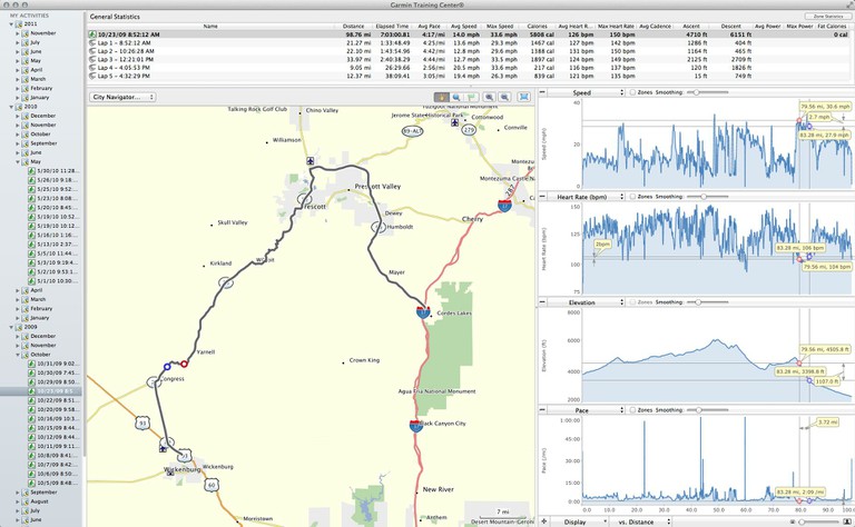
The power of these devices comes from the use of external software to analyse and archive the data they produce. I have been using a Garmin 305 for about five years. Almost all of the data has been saved both on Garmin's free on-line site, called Garmin Connect, and in Garmin Training Center, a free application available for both Windows and Mac OS X from Garmin. The two packages do similar but subtly different tasks. For example here is a screen shot of a ride I made from Cordes Junction to Wickenburg, AZ back on the 23rd of October in 2009.
The Garmin Training Center display is here (click to engraphify):
The Garmin Connect display here (click to enzoominate):
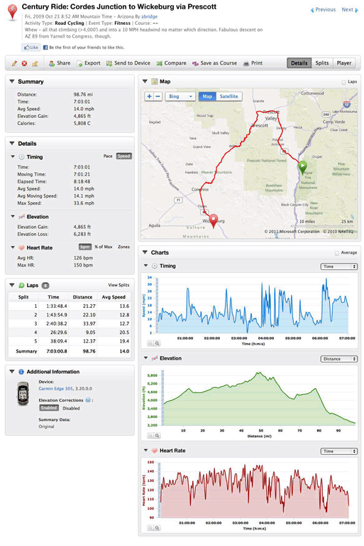
You will see that a wide variety of data has been collected. If I were using a power-meter that information would be available as well. The Garmin Connect site allows sharing through a variety of social media and a wealth of cataloging and other functionality.
If you're sharp-eyed you'll note that down in the lower left corner of the Garmin Connect display there is an option to correct the elevation data. That option is there because Garmin doesn't provide a calibration tool to set the pressure sensor in the 305 to a pre-determined value. Instead, Garmin attempts to set the elevation using the GPS information. Unfortunately this may not be sufficiently accurate. Since I was riding on highways for which accurate mapping data were available, Garmin was able to correct the recorded data. The original data was retained and can be restored with the click of a mouse. And a little time.
GPS-enabled cycling computers also allow for the planning and sharing of routes. On tours the planner can using mapping software to create a route and then share it with others in the group. Top of the line Garmin computers allow for the downloading of these routes so each rider can have turn-by-turn instructions making getting lost a little more difficult.
Phil Coleman shared this:
"A final Garmin story coming out of Dan Barcello's Oregon Tour. The ride from Hood River to Government is a 40-mile climb with whatever total elevation. One of our other riders programmed a feature in his Garmin that gave a continuous read of how many feet of climb we'd done, and how much was yet to go. That was when I told myself that I had to get one of these things."
Smartphones and Cycling Apps
New on the cycling scene are apps for smartphones: either iOS for Apple's iPhones or for GPS-capable Android phones. I'm not aware of cycling apps for the new Windows phones although they cannot be long in coming.
Smartphones bring faster processors and more memory along with more screen real estate to the cycling computer. They do it at the expense of size and weight. A GPS-enabled smart phone can be just as accurate as a GPS-enabled cycling computer. A smart phone can also be quicker at finding its initial position because it can use the cellular data network to help it quick a quick fix. The gathering of this kind of data, and the failure to discard it, got Apple in a lot of trouble earlier in the year.
Unfortunately there's a down-side for smartphones: they don't do elevation as well as you might want because no smartphone I know of has an internal pressure sensor although I'm seeing ads for sensors that might be used in future phones. As a result you live with the basic accuracy of GPS and all its foibles: accuracy that varies with how much of the sky is in view, where the satellites in the visible constellation are located, and a variety of other issues that affect accuracy. The result: I did a ride around Davis and was told I had climbed 1,700 feet while my Garmin 305 GPS cycling computer suggested that the number was more like 45. This alone makes me wary of using a smartphone as a data source for climbing.
Smartphones, of course, can interface with cadence and speed sensors and power meters. But they need a plug-in device to make that happen. I have an iPhone 4 and I've been using a Wahoo Fitness makes the Bike Case that will carry and iPhone 4 or 4S or 3GS. It's water proof and fully encapulates the iPhone while providing access to the headphone jack and providing a mini-USB connector for supplying external power for long rides.

- The Wahoo bike case

This case works fine, but in my experience it's just plain HUGE when mounted on a bike's handlebars. Like any iPhone interface it doesn't work when using full-fingered bike gloves. The result: I end up carrying the iPhone in the case in a rear pocket. If I had the choice to make again I'd have purchased the Wahoo Key. This is a small device that fits into the base of the iPhone and allows connection to any device that supports ANT+ protocols just as the Bike Case does. I could then just put it inside a ziplock back and carry it in my back pocket.
Why would I do this when I already have a perfectly good computer in the Garmin 305? Because for long rides the Cyclemeter app has some pretty wonderful features, not the least of which is its ability to e-mail at specified intervals where I am. I often ride alone. When I'm out on the road for hours at a time it seems a Good Thing for my wife to know where the heck I am in case I end up unconscious in a ditch somewhere and no one notices me. At least she'll have a clue about where to start looking for me. I also get a route I can save and share without the need for a computer between me and the internet. The Bike Case provides an interface to my heart-rate and cadence sensors so the phone can record that data as well. It will also record power-meter data.
Some screen examples from Cyclemeter demonstrate some of the software features.

- Stopwatch display. Click for larger image.


- Example graphs. Click to engraphenize.


- The route function. Click to enlarge.


- The update feature of cyclemeter.

In review
The traditional bike computer with a pressure sensor, and a GPS-enabled bike computer with a pressure sensor provide the most accurate climbing data. A smartphone has a wider range of features and some communications capabilities that the other two devices cannot touch but at this stage it's accuracy in measuring elevation data isn't particularly good. When smartphones come with pressure sensors then they will compete well although they will still be large and heavy compared to their built-for-purpose alternatives.
At this point I'm strongly leaning toward the functionality of built-for-purpose cycling computers like the Garmin 800. It's very flexible, can be used with fully gloved hands, has a decent battery life, is small, and measures elevations with reasonable accuracy. In the summer, on long solo rides, the capabilities of smartphone apps become more important.
